
An update to Oil & Energy’s 2021-2022 temperature forecast
Back in October, I listed the most likely outcomes for the Northeast winter season. Here they are again with some slight modifications:
- A second year La Niña will drive the 2021-22 North American winter pattern.
- Mid-December into early/mid-January is the most likely time frame to see colder than normal conditions across the central and eastern U.S.
- December heating demand is likely to run near normal, as a back-and-forth pattern, typical of a La Niña, dominates the early winter season.
- By mid-January, we are likely to transition into an above normal pattern.
- Early and mid-February are expected to feature widespread warmth across the central and eastern U.S., along with lower-than-normal heating demand.
- Pattern reversal to a colder than normal regime is expected to occur during the mid- and late-February period and last into mid-March.
As seen below, as of November 21, 2021, a classic La Niña signature in place across the Pacific.
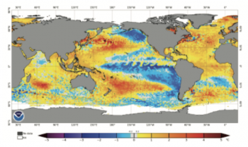
Note the horseshoe pattern featuring a tongue of colder than normal water running from the South American coast westward along the equatorial Pacific, with warmer anomalies noted north and south of the cold zone. This represents a strongly locked in La Niña.
As I have stated many times — and as we have been seeing since early November — La Niña events like to flip back and forth between two favored upper air configurations.
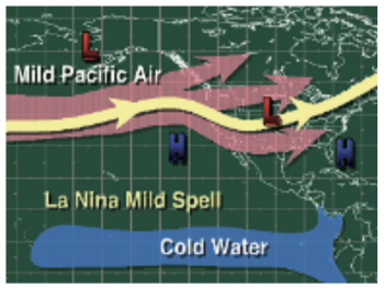
The warm mode favors eastern Pacific troughing with a broad zone flow of mild Pacific air across the U.S. During the warm mode, the northern tier of the U.S., including the Northeast, averages warmer than normal, with the greatest warm departures often centered on the North-Central states.
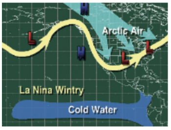
The cold mode favors an Aleutian or western Canadian upper-level ridge. This allows polar and/or arctic air streams to drop southward into the central and eastern U.S.
Warm Phase Look
Cold Phase Look
As I write this update in late November, the cold phase has been edging out the warm phase. The pattern from November on into early December has been a classic one featuring both sides of the La Niña signature. The cold intrusions have been solid, but not extreme, and have been replaced by solid warming periods, a couple of which produced scattered areas of late season record warmth.
While the cold intrusions can lead to some noteworthy below normal periods, you can never underestimate the ability of a La Niña to produce warmth.
What you rarely see with a La Niña is a very stable pattern. It is all about trying to time the transitions in and out of the cold and warm periods.
The modeling continued to favor the back-and-forth nature of the current La Niña holding through early December. And while late November was finishing on a cold note, there were strong signals that a classic La Niña warming period would occur during the early part of December. By the time you see this article, it should have already happened or be in its diminishing mode.
Given the behavior of some past La Niña events and the analogs they suggest, I have been favoring December into early and mid-January as the most likely time for the Northeast to experience an extended run of normal to modestly colder than normal conditions. I will modify that to the mid-December into mid-January time frame, given the likelihood that early December trends above normal.
The most recent European model 30-day prediction I could view while writing this article is for the December 8, 2021 through January 7, 2022 period. It is shown below.
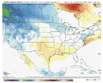
Note that this model shows an expansive area of near normal to somewhat colder than normal conditions running from the central and northern Plains eastward across the Midwest, Great Lakes, Ohio River Valley on onto the Northeast and Middle Atlantic regions.
This strongly suggests that the mid-December into mid-January period is the first time period to watch for an extended normal to colder than normal pattern to set up.
It should be noted that long-range modeling often has a difficult time catching cold periods until they are ready to unfold. Given the large coverage of at least normal conditions predicted by the Euro model, this suggests to me there is ample room for a significantly colder outcome than now modeled.
Lastly, the very cold conditions being predicted for all of central and western Canada cannot be dismissed. This cold loading across western Canada will need to be carefully monitored.
If a decent blocking pattern develops as we move through late December on into January, and if the Polar Vortex were to become disturbed, we could see bitter cold get unleashed into and across portions of the central and eastern U.S.
While I am always wary of the amount of warming that can develop during the course of a La Niña winter, we cannot forget how brutally cold it got last February across portions of the central and east-central U.S. Even during warm La Niña winters, periods of bitter cold can develop.
So, my latest call is for a warming period early in December that fades into an extended period normal to modestly colder than normal conditions during the mid-December to mid-January period.
As we move through mid- and late-December, I will be closely monitoring the upper-level pattern across the northeast Pacific and looking for signs of blocking, Stratospheric warming or Polar Vortex disruptions.
John Bagioni provides 10-day temperature and heating degree day forecasts, storm updates and webinars to heating fuel dealers via the Northeast Energy Weather Service, available FREE to NEFI members with their annual membership dues. Visit nefi.com/join to join NEFI or email benefits@nefi.com for more information.
