Second consecutive La Niña seen emerging during early 2021-22 winter forecast
Let’s get right to it! If I had to commit to a winter forecast as I was penning this article back on September 27, here would be my conclusions.
- A second year La Niña will drive the 2021-22 North American winter pattern.
- December into early January is the most likely time frame to see colder than normal conditions across the central and eastern U.S.
- Heating demand is likely to run above normal during December across the Northeast.
- January is likely to transition into a normal to above normal month, especially from midmonth onward.
- February is expected to feature widespread warmth across the central and eastern U.S., along with lower than normal heating demand.
- Stratospheric warming during the early part of the winter could produce a disrupted Polar Vortex and enhanced blocking, which may increase the existing potential for cold temperatures.
All of the current oceanic, atmospheric and modeling trends are onboard with a second year La Niña. As a quick reminder, a La Niña event refers to the equatorial Pacific Ocean averaging colder than normal. Like its cousin El Niño, La Niña events come in many different flavors, and there are always differences from one La Niña to another.
Questions to be answered over the next four to six weeks include: 1) How strong will this season’s La Niña cold anomaly be; 2) Will it be east or west based; and 3) Is it expected to weaken or strengthen during the course of the winter.
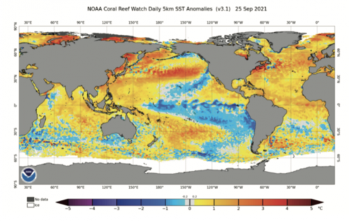
Atop the next column is a chart of the Pacific sea-surface anomaly as of September 25, 2021.
Note the clearly defined La Niña signature, a cold anomaly (in blue) stretching from the west coast of South America westward into the west-central Pacific. Right now, I think the following points are valid.
- The La Niña will peak later this fall or very early in the winter season as a weak to moderate event. It will not become a strong La Niña.
- It will be centrally based, but might trend eastward as the winter progresses.
- It will enter a steady weakening phase as we move through the midwinter on into the early spring period.
Again, no two La Niña events will be identical, and it is likely this one will differ somewhat in terms of its pattern impacts compared to last winter’s La Niña. But there are some fairly basic points about La Niña events that seem to almost always play out:
- They tend to have two favored upper air configurations.
- Both configurations usually occur for extended periods of time each winter.
- The warm mode favors eastern Pacific troughing with a broad zone flow of mild Pacific air across the U.S.
- During the warm mode, the northern tier of the U.S., including the Northeast, averages warmer than normal, with the greatest warm departures often centered on the North Central states.
Last winter, the warm mode was favored from late December on through mid-January.
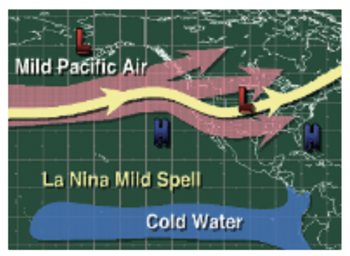
Warm Phase Look
The cold mode favors an Aleutian or western Canadian upper-level ridge. This allows polar and/or arctic air streams to drop southward into the central and eastern U.S. The position of the western ridge in the cold phase is critical to where the arctic air plunge will setup. If it is too far west, the cold plunge favors the Pacific Northwest into the western Plains, with the Midwest and Northeast not experiencing much in the way of direct arctic intrusions.
But if the ridge is further east or shifts into western Canada, a very cold period can develop from the Northern Plains into the Midwest and Northeast.
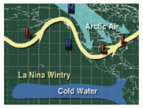
Cold Phase Look
Last year’s La Niña saw significant high latitude blocking. When high latitude blocking occurs during a La Niña winter, it opens the door for some very impressive cold periods. This was very much evident last winter when we saw an incredibly cold pattern overwhelm much of the central U.S. from very late January well into February.
Here is how February 2021 ended up!
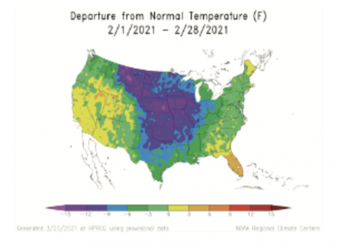
Note the bitter cold anomaly across the midsection of the country. This bitter outbreak was the product of a La Niña cold phase featuring a strong western ridge along the western Canadian coastal plain during a prolonged blocking period. The block directed the coldest air southward right into the Plains. Some cold did bleed eastward, but once east of the Ohio River Valley, it was greatly modified.
I suspect we are going to see another powerful cold period this upcoming winter season. But given the uncertainties about where the upper-level ridge will be during the La Niña cold phase, it is nearly impossible to state with confidence if it will mimic last year’s location, or shift further east.
***
While it is very difficult to gauge the strength and frequency of this winter’s high latitude blocking far in advance, there are hints it will be noteworthy. The greater the frequency of the blocking mode this winter, the higher the potential for extended periods of colder than normal conditions across the country.
One of the things that has caught the eye of long range forecasters recently is the prediction for several months now that the Stratosphere will undergo warming during December. Stratospheric warming events are often the precursor to blocking periods, as the Polar Vortex weakens during the warming.
The UKMET model is one of several that forecasts a warmer than normal stratosphere during November.
Normally, I would not put a lot of faith in this type of projection months in advance, but the forecast by the UKMET is in line with some other models, and it has been very consistent in showing this warming through numerous forecast cycles. Research indicates that when that happens (successive model runs showing the same outcome) the likelihood of verification is high.
If the projection for a stratospheric warming event to occur during November and December is correct, we are likely going to see a significant cold period develop early this winter, anytime from mid-December onward into mid-January.
Another indication favoring a cold start for the 2021-22 winter season is the pattern trend this past spring. There appears to be a good correlation between cold April/May periods and cold conditions returning the following December during a La Niña event. So, could this past April/May cold bias be an additional tip-off to a cold December?
***
As I write this first draft of my winter outlook in late September, I have only started to scratch the surface of all of the factors that need to be assessed moving into and through October. But if forced to summarize my first thoughts of the upcoming winter season and its impacts on the energy sector, here is what I would highlight.
- Colder than normal conditions, on average, from the Plains on across the Great Lakes, Midwest and Northeast from early/mid-December into early January. If the stratospheric warming signal is verified, and if it coincides with the cold phase of the La Niña, then a much colder-than-normal start to the winter would be possible. This means I could be underestimating the potential for a much colder-than-normal December into early January period.
- December into early January heating degree day totals are projected to average modestly above normal, up 1.5% to 3.0%.
- Highly variable conditions for the U.S. from about January 10 on through the end of the month with most areas averaging modestly warmer than normal. Heating demand would run 1.5% to 3.5% less than normal. This is based on my belief that the warm phase of La Niña will start unfolding during January.
- Right now, I favor the last month of winter seeing the most significant warm phase of La Niña. This means, right now, I expect February will be the warmest month of the winter for the central and eastern U.S. The western U.S. would be the favored area for cold. The call then is for February to average above normal to well above normal across the Northeast with heating demand running 5% to 8% less than normal.
As always, small shifts in the La Niña pattern and its impacts on the North American upper-level flow regime could significantly change how things play out. I will use this first assessment as my background pattern and adjust, if necessary, as we move into the mid/late fall period.
John Bagioni provides 10-day temperature and heating degree day forecasts, storm updates and webinars to heating fuel dealers via the Northeast Energy Weather Service, available FREE to NEFI members with their annual membership dues. Visit nefi.com/join to join NEFI or email benefits@nefi.com for more information.
