El Niño returns, and could bring significant winter weather in early 2024
After a three-year run of La Niña winters, Mother Nature has decided it is time to get back to a full-fledged El Niño winter, and that will be the case for the late fall/winter season of 2023-2024.
While we at times tried to will the past three La Niña winters to trend colder than normal across the Northeast, that was mostly a losing proposition. La Niña winters tend to concentrate significant cold periods, if there are any, across the Pacific Northwest eastward into parts of the Northern Plains, maybe even the western Great Lakes.
As for the Northeast, it is always a challenge to get sustainable cold periods during a La Niña pattern and that certainly was true over the past few winters. There can be, and were, some short and impressive cold intrusions, but the large-scale pattern associated with the La Niña could not stabilize into a long-running cold regime for the Northeast. And when all was said and done, winter temperature averages stayed skewed above normal.
La Niña vs. El Niño
First a brief refresher about what a La Niña is versus an El Niño. A La Niña pattern features a colder than normal sea-surface anomaly across the equatorial Pacific. An El Niño is the opposite and features a warmer than normal sea-surface anomaly across the equatorial Pacific. Here is the current (Figure 1) sea-surface anomaly pattern across around the globe.
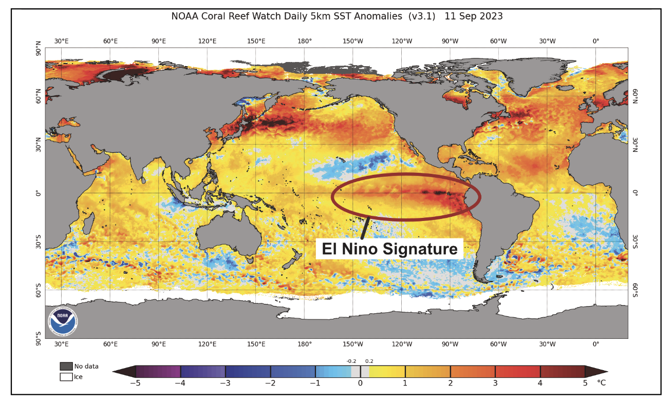
Note the warmer than normal tongue of sea-surface water running east to west from the west coast of South America on into the central Pacific. That is a classic look for a developing El Niño.
As one might suspect, no two El Niños are identical and the location of the core of the warmest water can play a significant role in how the atmosphere above the Pacific Ocean on into North America behaves. El Niño patterns that feature the warmest waters close to South America tend to favor warmth across the Northeast, as opposed to El Niños that see the warmest water across the western portion of the equatorial Pacific.
What’s Coming Next
Right now, the warmest waters (compared to normal) are close to the South American coastal plain, which would suggest a negative impact on Northeast cold potential. But, and it is a big but, most data indicate the warmest anomaly will migrate westward into the central and western Pacific during the course of the winter. That could tip the scales for more cold air production during the mid and late winter periods (January and February), as opposed to the early winter (December).
Also, the strength of the El Niño (how warm the water gets) is a big player. In general, weak to moderate El Niño events are more favorable for a “normal” to possibly colder-than-normal Northeast winter. Strong or what might be termed Super El Niños (exceptionally warm sea-surface temperatures compared to normal) tend to make it very difficult for a cold Northeast winter to occur. Often, strong El Niño events produce widespread warm winter conditions across the U.S. Right now, modeling trends are supportive of at least a moderate El Niño; maybe borderline strong but not a full-blown Super El Niño.
So where do we go from here? I will predicate my first winter overview on the El Niño reaching at least moderate strength and shifting from an east-based event early on into a west-central based El Niño as the winter progresses.
1. For the late fall / early winter period (November & December), this suggests a somewhat milder than normal start to the cold season overall. This does not mean record smashing warmth for the Northeast, but it does imply the likelihood of extended well-below-normal conditions during the November / December period are less likely than climatology would usually allow. This also does not mean NO COLD for November and December. There will be cold periods, it is just unlikely they will lock into any truly long-running cold. This assumes we see an east-based El Niño during the late fall and early winter period.
2. If we are on the right track for the El Niño trends, we will then have to consider at least a near normal January through February period; possibly lingering into March. The move toward a “normal” mid / late winter period opens the door to the potential for extended colder than normal cold periods. We do not have to have truly bitter cold to end up with a decent, seasonably cold mid / late winter. There is always going to be variability and a back-and-forth temperature pattern during the course of a winter. But a western or central based El Niño could lead to a more “normal” Northeast winter. Of course, any move into a Super El Niño would blow up the chance of a normal second half of winter.
3. Also, we have to also consider the possibility that our warming climate will prevent even a well-positioned El Niño from producing normal winter cold. I think if we end up with a central to western based El Niño of modest strength along with some of the other features now being modeled for the winter upper air pattern, and we do not get close to normal mid / late winter conditions, I will start raising the White Flag. That means if we end up with a historically favored El Niño position and strength and fail to capitalize, it will be very telling.
Modeled Upper Air Pattern
Surprisingly almost of all of the major long range modeling schemes have the same basic upper air prediction for the upcoming mid / late winter period.
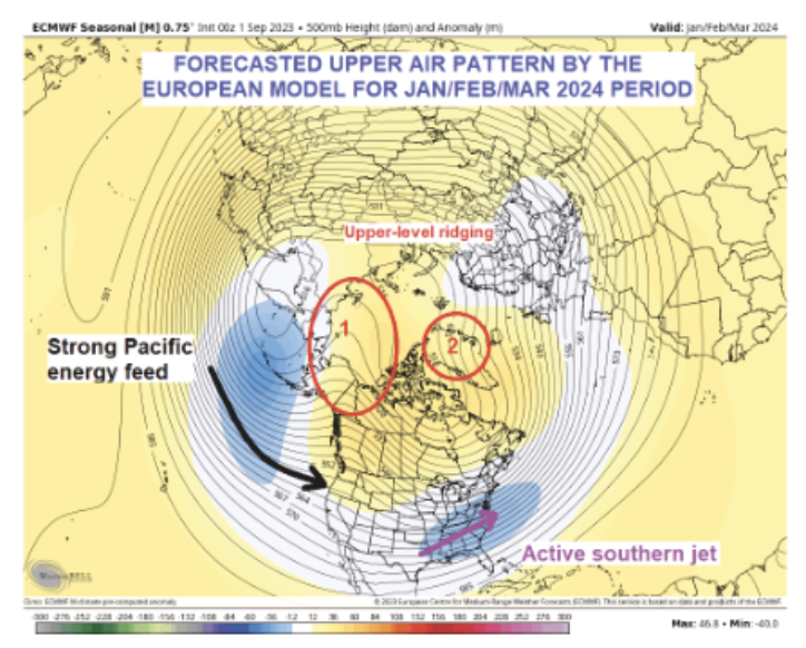
Figure 2 is the European (ECMWF) forecast for the upper level, averaged out for the January, February and March 2024 period.
- Note the pronounced upper-level ridging; point 1.
- Note the ridging over Greenland; point 2.
- Note the active Pacific energy feed and the lower heights across the Deep South northward to the Middle Atlantic region.
- The ridging noted at point 1 suggests a pattern favorable for significant cold air production across western & central Canada. The polar jet would be suppressed southward by the blocking ridge at point 2. This would favor cold air mass production in western Canada spreading southeast into the Great Lakes, Ohio Valley and Northeast.
- The strong Pacific jet showing up indicates a strong feed of Pacific energy into the country that provides for frequent storm formation in the Midwest and Deep South that migrates to the East Coast. This is a very active winter storm look!!!
- One of the things that has caught my attention is the multi-model support for this type of pattern. Often you see models varying wildly prior to the onset of the winter. In this case, they all are painting a similar picture. Maybe they are all wrong? But you have to base your outlooks on the pattern being modeled and right now there is lots of support for the upper air pattern noted in Figure 2.
Final Thoughts
In summary, as I pen this outlook in mid-September, I am fully aware that things may change and the possibility that once again the specter of climate warming may alter what looks to be a normal to colder than normal, and stormy mid / late winter pattern.
But all I can do is tell you what the pattern trends are suggesting and continue to monitor and update it moving forward.
I am not looking for a meaningly cold late fall / early winter pattern (November / December) but certainly see signs the January into March period could feature a more significant period of winter weather and winter storm activity than we have seen over the past 3-years.
John Bagioni provides 10-day temperature and heating degree day forecasts, storm updates and webinars to heating fuel dealers via the Northeast Energy Weather Service, available FREE to NEFI members with their annual dues. Visit nefi.com/join to join NEFI or email benefits@nefi.com for more information.
