EDITOR’S NOTE: The last two winters have featured extreme weather, such as the severe cold that enveloped the northern United States in 2013-14 and the heavy snowfall that buried Boston in 2014-15. Early chatter about winter of 2015-16 has focused on the El Niño forming in the Pacific, with many forecasters discussing the likelihood of a mild winter.
With so much as stake for energy marketers, Fax Alert Weather Service Meteorologist John Bagioni is weighing in with an early look at factors that could drive the weather for the upcoming heating seasons.
Headline Points
- Strong El Niño conditions will be the primary driver of this cold season’s pattern into the late fall/early winter period.
- Normally this means a widespread warmer than normal winter season lies ahead for much of the country… But given the long-lingering North Pacific warm pool, western Canadian upper-level ridging could once again develop and offset some of the normal strong El Niño outcomes across the Northeast sector of the country, especially during the second half of the winter.
- There will be a tendency for many forecasters to broad-brush a warmer than normal winter for the country as a whole, but I am wary of dismissing the long-running trend for western Canadian ridging, given the persistence of the north Pacific warm pool profile.
- At this point in time, I will hedge my bet for a close-to-normal Northeast and New England winter season with the majority of the cold occurring during the second half of the winter — much like last year.
- I will also leave the door open for a return to a solidly colder than normal winter pattern after a fairly benign and mild December.
- It also looks like a very stormy winter for the eastern third of the United States as the El Niño ignites a very active southern stream energy source.
Discussion
As always, I have to urge readers of this discussion to remember a couple of things.
- When a winter forecast or outlook is made, it is trying to convey an idea about how the three-month period from December through February will play out, on average. It does not indicate how every signal day will feel!
- Secondly, large-scale pattern trends have to be frequently assessed and analyzed for changes as we move into the mid and late fall season, and the winter outlook will need to be adjusted and/or modified as need be.
- Thirdly, it only takes relatively small shifts in the position of some of the large-scale atmospheric players to completely change a winter forecast. This year is even more worrisome in that respect, since we will be fighting one of the most dominating North American weather controllers: a strong El Niño.
November
Many El Niño falls see a turn to colder than normal conditions during November. Frequently this cold turn makes folks think we are locked into a cold December and/or winter. That is usually not the case though, at least with regards to December. You might recall last November trended cold but December shifted strongly into a milder than normal month. This year I am looking at the likelihood of an El Niño-driven colder than normal November. The degree of the coldness in November is hard to quantify at this time, but a solidly colder than normal month is within reason. Also like last November, I think an early snow threat will be in play. Last year it was during Thanksgiving week! Obviously there is no way I can even take a wild guess about when a November snow event may happen this year, but one will likely be in play.
Winter 2015-16 Discussion
If you are unaware of the fact that a strong El Niño event is underway, I will assume you have had no access to news or the Internet for the past six months. Last year we had a weak El Niño in play; this year we are dealing with a very strong, potentially historic, event.
At first blush, that would seem to make for a very easy winter forecast across the country: Just call for widespread warmth! In the end, maybe that is all that needs to be said. But this might be one of the years that a simple, strong El Niño analog winter forecast will not work for the Northeast sector of the country. Here are the typical strong El Niño highlights:
- Very warm from the Pacific Northwest on eastward across the central and northern Plains into the Great Lakes region with a somewhat less warm signal further east, but still above normal temps for the Middle Atlantic and Northeast/New England regions.
- Cooler than normal conditions across the Deep South; mainly due to above normal rainfall and abundant cloud cover, not cold air intrusions from the north.
- Very stormy conditions across the Deep South and eastern half of the country.
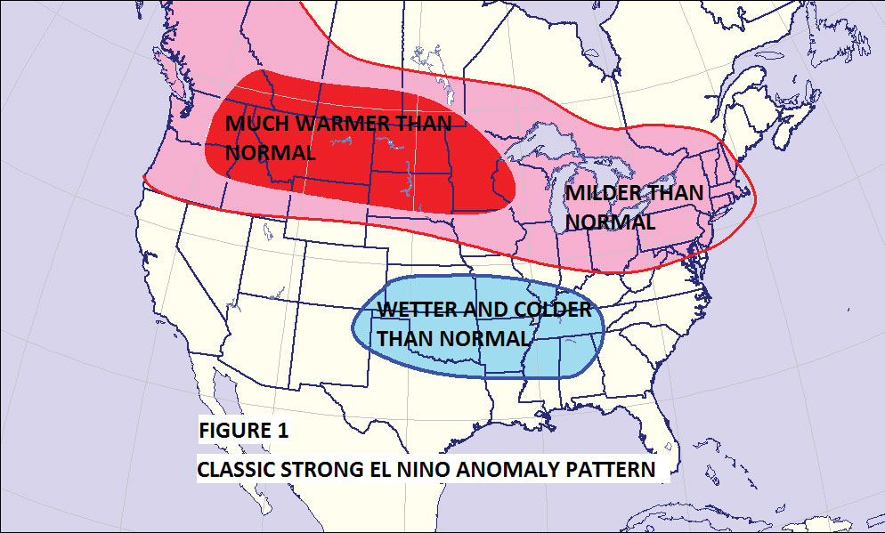
Figure 1 shows what I think the wintertime temperature anomaly pattern will look like if the El Niño signal is unopposed. If there were nothing else in play, the three bulleted items above would be my winter forecast overview. But there are other things that need to be considered this year, which may well alter the typical strong El Niño analog. Here are three factors that could steer the forecast, with a discussion of each one.
1. North Pacific Warm Pool
We are now going on Year 3 of a decided North Pacific warm pool. This warm anomaly configuration across the North Pacific has been largely (not completely) responsible for the frequent western U.S. and western Canadian ridging of the last two winters. The western ridging has been the big player in the steady stream of very cold air mass intrusions that have moved into the central and eastern U.S. over the course of the two previous winter seasons. I read an article a year or so ago that seemed to support the North Pacific warm pool occurrence having a three-year lifespan. Last fall, I was worried about its footprint fading. That did not turn out to be the case, and the cold intrusion pattern actually intensified for portions of the eastern U.S.
Given the latest look of the North Pacific temperature anomaly pattern, I think we have to assume it has a decent chance of staying in place for the upcoming winter season. Last winter the North Pacific signal only had to battle the impact of a weak El Niño. This year it will be trying to offset a powerful, if not historic, El Niño. For this reason (at least right now), I am going to use it (North Pacific warm pool) as a counter-weight to the warming impacts of the El Niño, but not to overwhelm it like it did last year.
2. El Niño Configuration
Currently the El Niño is strongly east-based, meaning its warmest water anomalies are closer to equatorial South America than the equatorial zone of the central Pacific. Last year the El Niño very clearly became central Pacific-based. History has shown that eastern-based El Niño events favor warmer conditions across the U.S. than centrally based ones. If we end up with a completely eastern-biased strong El Niño event this winter, it is hard to believe the cooling impacts of the North Pacific warm pool could hold the warming back, and we would lose the chance of cold winter season across the Northeast sector of the country.
But several modeling schemes have been showing the warmest anomaly portion of the El Niño migrating westward closer to the central Pacific. Any westward shift of the core of the El Niño during the course of the winter would allow other factors and features to play a larger role in the winter pattern, especially once past December.
There is considerable agreement amongst the models that the El Niño will peak in intensity during the October into early December period with a sharp decrease in strength as we move into the heart of the winter season.
As with the westward migration of the core of the El Niño warm pool, a general weakening of an El Niño event during the second half of the winter has often been associated with cold signals gaining more of an influence.
Unfortunately there are no perfect El Niño models. This means we cannot count on the El Niño core migrating westward and a general weakening occurring as we move past December. It will become more obvious once into November, but right now these are things we can speculate about and hedge the forecast toward, but cannot say with certainty, at least not right now, that they will occur.
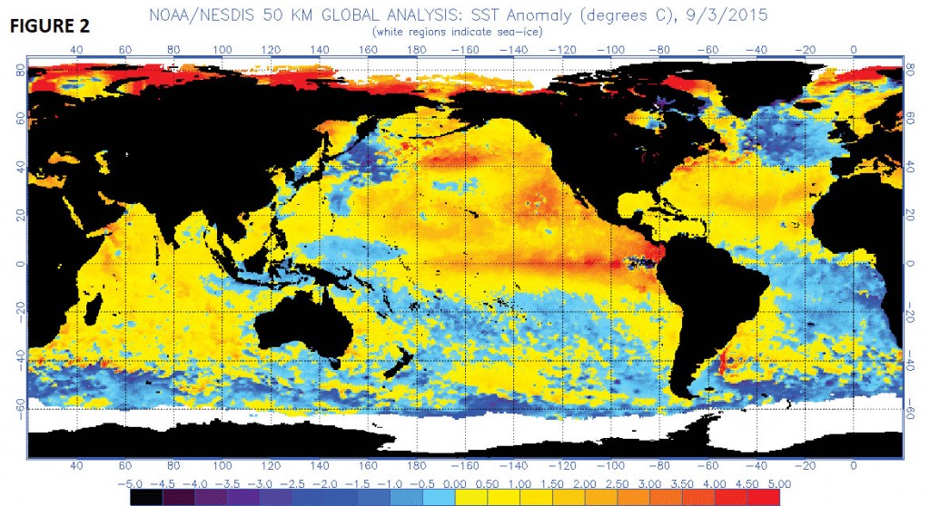
(Caption:) Figure 2 shows current sea-surface temperature anomalies.
Note the well-defined El Niño profile in Figure 2 with the warmest anomalies located in its eastern sector. Next, note the warm pool across the North Pacific with a small cool pool just to its south. That is a pretty classic signal for western Canadian or western U.S. ridging.
The El Niño look is very impressive, and if nothing else can counteract its presence during the winter season it will flood much of the U.S. with steady stream of Pacific-based air, which will in turn completely cut off any regular southward intrusions of arctic air.
What we will be looking at as we progress through the fall season will be for warmest anomalies in the El Niño to migrate westward and the warm pool across the North Pacific to stay intact. If does occur after the first of the year, we would once again be looking at the possibility of the Northeast sector of the country receiving frequent enough cold intrusions to skew the winter temperature pattern to normal or below.
It should also be noted that a powerful El Niño pattern like the one that is now underway across the equatorial Pacific usually fuels a very active southern jet stream, which then in turn leads to frequent strong southern U.S. storm formation. Whether or not we are looking at lots of big snow and/or ice events will be highly dependent upon the availability of cold air masses.
3. High Latitude Blocking
Attempts at accurately predicting the state of the high latitude blocking (-AO and/or –NAO) have failed miserably over the past two winters. Last year it appeared several features were pointing toward a very blocky winter, but in the end it was one of the least blocky winters.
Like the North Pacific signal, there is likely a cycle of occurrence with the blocking potential. It truly is a big wild card that has been historically hard to get a handle on! I can see the argument being made right now for more high latitude blocking this winter than the last two but just do not feel confident enough to make it a part of my forecast. In general, high latitude blocking enhances the potential for cold intrusions across the Northeast. Of course, it cannot be extreme blocking otherwise it allows parts of northern New England and eastern Canada to be overwhelmed with milder North Atlantic air masses.
With this in mind, I will not incorporate a blocking player in my forecast but will monitor it on a month-to-month basis. I will say, though, that if we do see a westward shift and a weakening of the El Niño and during the second half of the winter along with some modest blocking, another very cold winter period would likely evolve.
Leaning Towards Cold
But I am not sold on a classic El Niño winter! Yes, it will be the dominating factor, especially through December, but I am going to assume it weakens considerably after the first of the year and the North Pacific warm-pool-induced ridging signal works with at least modest high level blocking to change the tenor of the winter season as we move through January, especially from late January onward.
Many folks have already forgotten that December 2014 ran very warm across most of the Northeast, and true winter conditions did not set in until the last 10 to 15 days of January. Once they did develop it led to an historic cold period with February becoming one of the all-time, if not the all-time, coldest month in history for portions of the Northeast.
It is hard to imagine the atmosphere doing that again, and currently I am not indicating we will see a late January flip into harshly cold winter pattern, like last year.
But I am currently favoring a colder trend after a warmer than normal December with the real possibility that the three-month winter average (DJF) can end up close to normal, if not somewhat colder than normal by the end of February. It may also mean that the three-month late winter period of January through March could trend solidly colder than normal
One of the products that I think has done a very reasonable job in showing the winter trends is the Constructed Analog Method. This method takes the current global sea-surface temperature pattern every month and matches them with the best upper air flow and surface temperature anomaly patterns several months ahead based on past history. This is what the most recent projection showed for the January through March period.
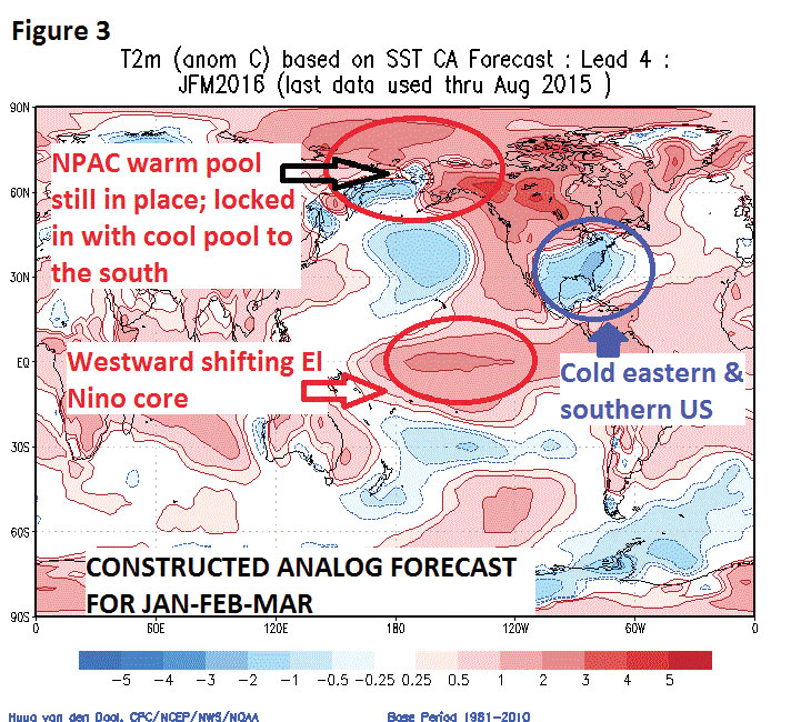
(Caption:) Figure 3 shows Projected Sea-Surface Temperature Pattern for mid/late winter.
Figure 3 shows the core of the El Niño warmth weakening and shifting westward into the central Pacific and the North Pacific warm pool locked in place due to a cold pool to its south. The resulting upper air pattern would likely feature a deep eastern U.S. trough and a semi-permanent western Canadian upper level ridge. It goes on to predict a very warm western U.S. but a widespread cold eastern regime.
If the Constructed Analog modeled features are correct, a decidedly colder than normal second half of winter for the eastern U.S. would result. While it did real well last winter, I am not ready to hang my hat on its prediction just yet. I will start moving away from the classic strong El Niño warm winter outlook, but right now will only make small adjustments in the El Niño pattern, knowing full well I may need to continue the trend down the road.
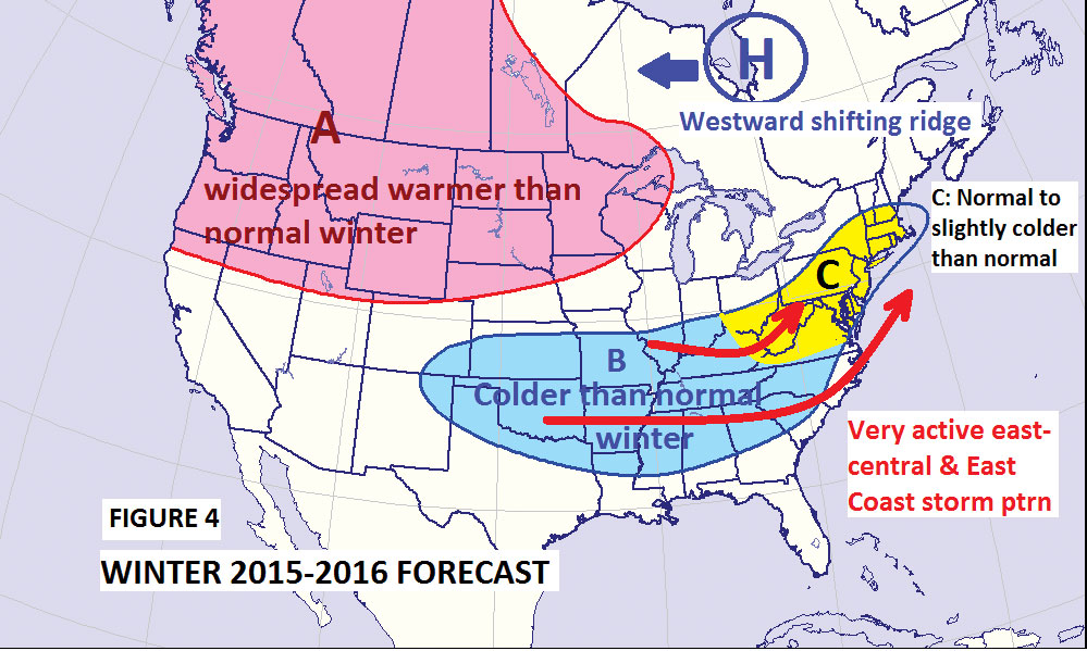
(Caption:) Figure 4 shows the pattern I am comfortable going right now.
Figure 4 shows the pattern I am comfortable going right now. I will indeed leave the door open for a further cold adjustment as the fall pattern starts to mature and we can look at the monthly changes in the El Niño configuration.
Here is my starting point! I will cut back on the eastern extent of the north-central U.S. warmth and allow the colder than normal zone expected across the Deep South and South-central U.S. to expand northeastward into the Middle Atlantic region, parts of at least southern and southeastern New York, and portions of southern and central New England.
Please remember this is what I think the winter averages will look like at the end of February 2016.
Conclusion Highlights
- Widespread warmer than normal conditions on average across the Pacific Northwest, western Canada and the Northern Plains into the western Great Lakes.
- Cooler than normal conditions across portions of the Deep South, South-central states on northeastwards across the Middle Atlantic region, parts of southern and eastern New York and much of Southern New England on into parts of Central New England.
- Widespread eastern U.S. and East Coast storminess.
Northeast Highlights
- December averages warmer than normal.
- Pattern trends seasonably cold, possibly solidly colder than normal from about mid-January onward.
- Coldest month of the winter is February.
- Colder than normal conditions linger into March.
- Above-normal precipitation with several strong eastern storms and/or nor’easters.
- Potential for normal or above normal snowfall season will be in play, but given some uncertainties about the degree and closeness of cold air masses, the potential for messy mixture storms and ice will be greater than last year, as well as snow-flipping-to-rain storm events. Once again we are likely to see some potential for an enhanced snowfall area, but whether or not the best snow potential this year will exist southward across the interior Middle Atlantic region or somewhere across New York and New England is not predictable at this time. The bottom line is I expect a very active eastern U.S. storm season.
Meteorologist John Bagioni of Fax-Alert Weather Service can be reached at (860) 675-9091 or john@faxalertweather.com.
