
Lack of prolonged wintertime cold continues across the Northeast
You have to go back to either the 2013-14 or 2014-15 winters to find a pattern that was favorable for persistent, long-lasting cold periods in a widespread fashion across the Northeast. We are always very good at determining what went wrong, but struggle to predict well ahead of time when a fall pattern that looks promising for meaningful midwinter cold will fail.
Last year once again featured a fall pattern that favored solid colder than normal conditions across much of the Northeast. And as we were moving through the fall season, the ducks on the forecasting pond seemed to be lined up for at least an average (normal) winter, and very possibly a colder than normal one. But, for the second year in a row, a large-scale pattern across the Northern Hemisphere and Pacific Ocean that looked very promising during November and early December fell apart as we moved through late December, leaving us with an unfavorable pattern for sustained cold once into January.
While there are several ways a colder than average winter can evolve across the Northeast, I have long favored a weak to moderate El Nino (warmer than normal equatorial Pacific water) and a solid warmer than normal pool of water across the northeast Pacific basin. Both of these features were in play during November 2019 and looked likely to continue into the midwinter period. High latitude blocking, especially across the North Atlantic sector, is a big plus, but is very difficult to predict and count on when assessing long-range feature development. I’ve reached the point where I do not build high latitude blocking into my long-range forecasting assessment unless there is an overwhelming consensus that it will occur, and that just does not happen. When it becomes a viable winter feature, I will try to modify my medium and long-range thoughts.
This past winter, as has been become the case recently, promising early signals faded, while other negative features appeared, and to cap it off, high latitude blocking went into hiding. When all was said and done, a below normal Heating Degree Day season was the result.
Ocean Temperature Anomalies
It does not take a genius to figure out that to get sustained cold into the Northeast you need a large-scale pattern that allows for persistent northwesterly jet stream flows from central and western Canada on into the Northeast quadrant of the U.S.
The most common way for that to happen is to have an upper level ridge sitting across western Canada and persistent upper level troughing across the eastern U.S. and eastern Canada. If you throw into the mix some high latitude blocking, especially across the North Atlantic sector, you have a recipe for Northeast cold. Of course, no upper air pattern lasts an entire winter! But if you can just get the upper level jet stream flow to occasionally feature western ridging for several weeks during the course of the winter, at least a normal or modestly colder than normal winter will result.
I have always favored a warm pool of water sitting across the northeast Pacific during the winter season as a signal that western Canadian upper level ridging was likely. But once it develops during the fall season, it must hang in there and not fade or shift further west into the north-central Pacific as you approach the heart of the winter season. If if fades or shifts west, the potential for persistent western Canadian ridging declines. High latitude blocking could help even if the northeast Pacific is not warmer than normal, but without it, the odds for sustainable cold delivery into the Northeast are slim.
Here is the look of the sea-surface temperature anomaly last November.
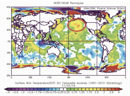
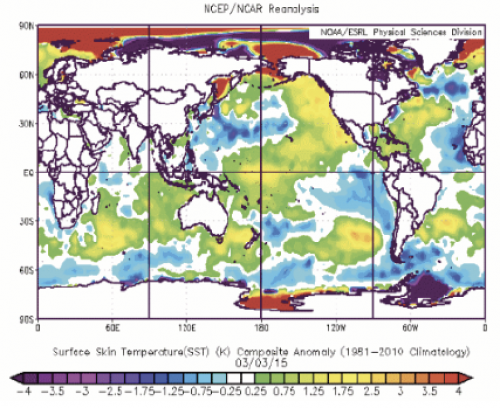
Note the solid warm pool sitting across the northeast Pacific. It was in an excellent position and looked to be a solid anomaly, which appeared to be a strong signal for a wintertime western Canadian upper level ridge. But take a look at what happened to it as we moved through the heart of the 2019-2020 winter season. Here is the anomaly on Mach 3, 2020.
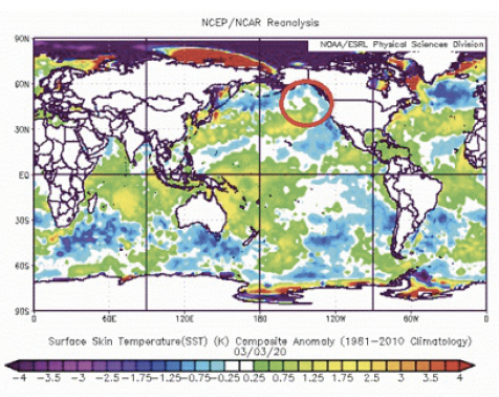
Note not only has the northeast warm pool weakened and shifted westward, but also cold anomalies have developed along the western coasts of the U.S. and Canada. While there are other ways to manufacture western ridging, that is a pretty ugly look and, in my opinion, not one I would like to see when looking for a cold weather pattern.
I would never say that to get a cold winter in the Northeast you must have a big warm water pool sitting across the Northeast, but historically it has been a good correlation factor and one that I would rather see than not.
This past winter the warm pool started weakening and shifting west as we moved through December. This is something I should have noted more strongly as I reassessed the January/February 2020 period. However, the modeling was very bullish on allowing strong western ridging to develop and called for at least normal wintertime temperatures across the Northeast, with the door open to extended solidly colder than normal periods.
Alas, in the end, the lack of western ridging and the absence of high latitude blocking destroyed the potential for a normal or colder than normal winter. While it is a what-came-first “the chicken or the egg” question, I believe the inability of the northeast Pacific warm pool to stay in place played a significant role in the winter trends.
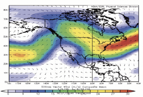
If you look at the mean upper level flow across the North America sector during the heart of the 2020 winter season, here is what you get.
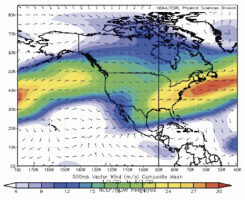
Note the basic flow across the country is rather zonal (west to east). This carries mainly Pacific Ocean air eastward across the country with little or no input from Canada. In fact, if you look across western and southern portions of Canada, the mean flow is from the Pacific, not from the Arctic. You cannot have a cold winter or even a normal winter if the basic flow across the U.S. originates from the Pacific Ocean.
The Last Cold Winter
Let’s take a look at what the northeast Pacific anomaly and upper flow looked like during our last truly cold winter, 2014-2015. Here is the northeast Pacific sea-surface anomaly pattern from November 2014 to March 2015.
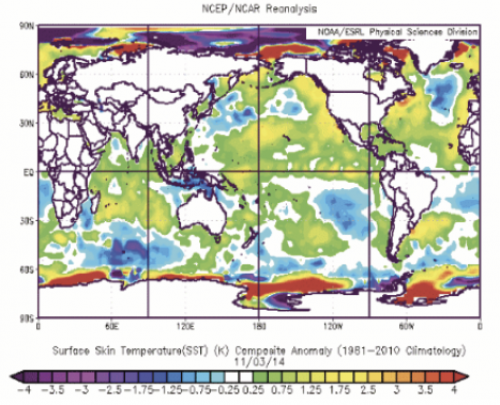
Note the northeast Pacific warm pool persisted and strengthened during the entire cold season! Here is the resultant mean upper level flow for the 2014-15 winter season.
Note the western upper level ridging across Canada, which helped promote a flow from the Arctic on into the central and Northeast U.S.
Now let’s compare the impact of the two different northeast Pacific anomaly patterns and mean upper air flows. Here is the Departure from Normal for the Heating Degree day total from December 2014 through February 2015.
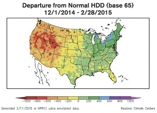
The result was a heating season that featured above normal Heating Degree Day totals across almost the entire eastern U.S. The core of the coldest winter anomaly and thus the greatest departure from normal Heating Degree Totals was from the central Great Lakes on eastward into New England along with Pennsylvania and New Jersey. This was very much a function of the warm anomaly across the northeast Pacific, which in turn helped promote and sustain western U.S. and western Canadian upper level ridging.
2019-2020 Play By Play
Now onto how the 2019-2020 Heating Degree Day season played out. Here is the Departure from Normal for the Heating Degree Day total from December 2019 through February 2020.
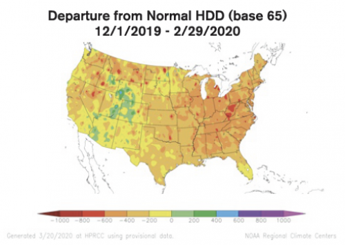
Other than small high elevations areas of the central and southern Rockies, the core of the heating season (December-February) featured lower to much lower than normal Heating Degree Day totals for the country.
As for the Northeast, the majority of the reporting stations ended up with a departure of generally 4-7 percent less than normal. This was a result of a persistent west to east flow dominated by Pacific air, likely in part caused by the weakening and westward shift of the northeast Pacific warm anomaly.
Again, I would never imply the northeast Pacific warm anomaly is the be-all and end-all of a Northeast wintertime cold weather predictor. But it does show up as a player when cold winters do occur. If high latitude blocking is not going to be a significant feature during a winter season, it (warm pool across northeast Pacific) is certainly something I look for when assessing cold potential.
Lessons for Future Forecasts
A lesson learned over the past two winters is that a favorable northeast Pacific pattern in November does not ensure it will remain through the core of the winter. Unfortunately, the best sea-surface temperature modeling available does not do a great job on projecting the state of the ocean anomaly patterns two to three months down the road.
I think long-range winter forecasting will continue to struggle for a variety of reasons. There are a multitude of factors that determine the outcome of a winter season. We do not by any stretch of the imagination have a handle on all of the factors that determine a particular winter’s pattern. Sometimes we think the general pattern that was in place one year will produce the same outcomes the next time it appears. It may not.
Add to all of the normal winter forecasting issues the role a warming planet — especially warmer oceans — plays, and I think it is likely that pre-season winter forecasting will remain a low confidence item.
John Bagioni provides 10-day temperature and Heating Degree Day forecasts, storm updates, and webinars to heating fuel dealers via the Northeast Energy Weather Service, available at a 50-percent discount to NEFI members. Visit nefi.com/join to join NEFI and nefi.com/store to sign up for the Northeast Energy Weather Service.
