
Winter 2021-22 heating degree day review
In terms of temperature departures and heating degree day totals, the 2021-22 winter season will be remembered as a book-ended winter. The numbers will show a solid colder than normal middle third of the winter, with a warmer start and a warmer finish, which produced a milder than normal season overall.
December
A plot of the mean jet stream flow for the month of December 2021 shows a classic west to east (zonal) flow, very common during a La Niña. During a La Niña year, it is never a question of whether or not there will be zonal flow periods, but how often will they appear and how persistent will they be.
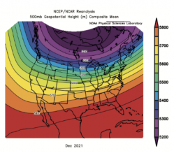
There were hopes prior to December 1 that the jet flow would be more frequently amplified during December and that amplification would lead to a few solid cold intrusions into the central and eastern U.S. But once the December 2021 pattern became fully established, it favored a persistent zonal flow appearance, and the cold intrusions across the central and eastern U.S. were limited and brief.
A zonal flow pattern like this allows mild Pacific air to overwhelm the central and eastern U.S. and usually leads to an above normal to well above normal temperature average.
Not surprisingly, the December 2021 temperature anomaly plot for the Northeast sector shows widespread above normal conditions ranging anywhere from +2° to +8°.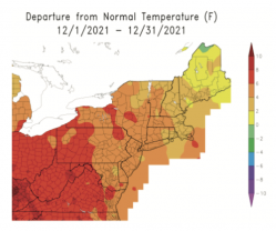
There were periods that did feature normal to briefly colder than normal air mass intrusions, but by and large the zonal flow effectively cut off the Arctic supply line.
I was not surprised by the evolution of the zonal flow during the early portion of December, but I expected it to fade and be replaced by a more amplified jet flow once past the midmonth period. However, that did not happen and the transition only slowly developed late in the month.
The impact on December heating degree totals was quite dramatic. The vast majority of the country saw negative heating degree day departures, owing to the persistence of Pacific air streams almost constantly flooding the country with milder than normal conditions.
Note in the December 2021 heating degree day departure map that widespread negative departures on the order of -160 to -400 were common across the country.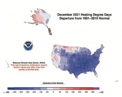 Most La Niña events feature very significant pattern flips during the course of a winter season and this one was no different. I’d expected the mid-December to mid-January period to run colder than normal before a flip to above normal conditions during the late January through mid-February period. However, once the zonal flow held its ground through mid-December, the flip to a colder regime did not show up until early January.
January
Once into early January, the zonal flow quickly changed into a more amplified regime featuring strong western U.S. and western Canada upper-level ridging and eastern Canadian and Northeast upper-level troughing. As said many times in the past, the favored jet stream configuration for Northeast cold is western ridging and eastern troughing.
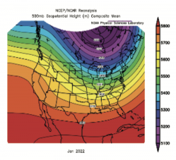
The January 2022 mean upper-level flow ended as a great example of a western ridge/eastern trough couplet. Given that the map is a 31-day average, the amplitudes of the ridge and trough are somewhat less amplified than they were much of the month. Note that the country is no longer dominated by a west to east flow of mild Pacific air. The main flow into the Northeast originates across far northwest and then sweeps southeastward into the Great Lakes and Northeast.
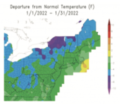 The January temperature departure was the result of this more amplified upper-level flow pattern. As indicated on the map, widespread cold anomalies in the range of -6° to -8° were noted across the northern and western tier of the region, with the rest of the Northeast ending the month with mostly -2° to -4° departures.
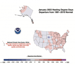 The colder than normal January anomalies allowed the Northeast heating degree day totals to run generally in the +100 to +200 range. But the January pattern change from December 2021 was not able to maintain itself into February 2022.
February
The February average upper air flow pattern was a mix of the December/January patterns. It was not a pure zonal flow from west to east and at first glance appeared to be a pattern that should have allowed more cooling across the Northeast than it actually did.
When you look at the February 2022 upper-level flow, you see solid western Canadian ridging and continuation of a deep eastern-central upper-level trough. This type of configuration usually allows for fairly frequent cold air intrusions into the eastern and northeastern U.S. But the western ridging was just far enough offshore of the West Coast to allow north-central Pacific air streams to modify the Arctic air coming southeastward out of northwestern Canada. If you follow the flow backward from the Northeast, you can see the point of origin is the northeast Pacific, not western Canada!
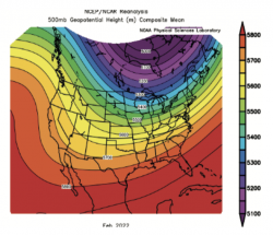 A very slight shift in the western ridge would have allowed February 2022 to average every bit as cold as January. Clearly, the February 2022 flow looked nothing like the mild zonal flow of December 2021. But again, the slight shift in the shape and amplitude of western ridging prevented a solidly colder than normal February from evolving.
For those of us looking for colder than normal conditions during the course of a winter month, I would roll the dice anytime with the mean upper flow that dominated February 2022. More times than not, widespread colder than normal conditions would prevail across the central and eastern U.S., but this time around, the position and amplitude of the western ridge was just off a bit.
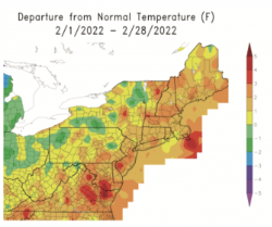 The February 2022 temperature departure map highlights the result of the out-of-position western ridge. While there are pockets of colder monthly averages across the Northeast, the majority of the region saw February run +1.5° to +3.0° above normal.
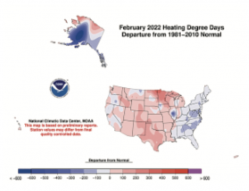 The February heating degree days departure map shows how close the month was to trending normal. Most areas across the Northeast saw total departures generally in the -50 to -100 range – not a huge hit to the degree day numbers, but still a warmer than normal month overall.
Winter Totals
For the 2021-22 winter season, heating degree day totals in the Northeast ended up being skewed below normal due to the combination of the very warm December and the modestly warmer than normal February. If December 2021 had managed to run only modestly milder than normal, the January 2022 cold period would have been able to keep the overall season fairly close to normal, but the heating degree day departures were just too much to overcome.
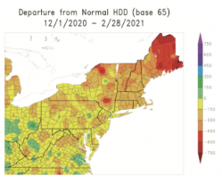 Overall, most of eastern New York and New England ended the season running a heating degree day deficit in the -150 to -350 range, with eastern Maine in the -450 to -650 range. Further west and southwest departures were less extreme, mostly in the -100 to -300 range.
I can’t stop thinking how close we were to a running a solidly colder than normal February, if only the western ridge had been a couple hundred miles farther east.
It is not unusual at all for La Niña winters to average milder than normal across the Northeast and this one was favored to skew warmer when the winter forecast was issued. But this winter came very close to being normal to modestly colder than normal. The much warmer December and inability of February to stay closer to normal given the basic look of the upper air flow were the keys to the winter skewing above normal.
John Bagioni provides 10-day temperature and heating degree day forecasts, storm updates and webinars to heating fuel dealers via the Northeast Energy Weather Service, available FREE to NEFI members with their annual membership dues. Visit nefi.com/join to join NEFI or email benefits@nefi.com for more information.
