
EDITOR’S NOTE: After a disappointing winter in 2015-16, Fax Alert Weather Service Meteorologist John Bagioni sees signals for a more hopeful season ahead, with a decent possibility for serious cold between last December and February, particularly in the western portions of heating oil country.
The Headlines:
• Analog trends suggest using the potent 2013–2014 winter as the primary background footprint.
• Keys will be strength of La Niña and position of north-central Pacific cold pool.
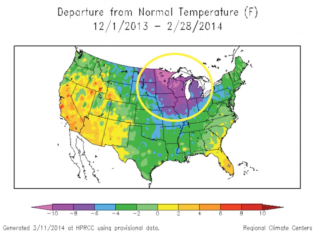
The first figure (right) shows what the 2013-2014 winter temperature anomaly pattern looked like by the end of February 2014.
The 2013-2014 winter featured a very impressive cold core centered on the Northern Plains and Upper Midwest on into the eastern Great Lakes. The winter started off very cold in the north-central states and the colder than normal conditions expanded eastward with time and eventually overwhelmed the entire Northeast.
Current atmospheric trends and some modeling forecast trends suggest using the 2013-14 winter as a primary analog for this winter. That does not mean taking the 2013-14 winter pattern verbatim! It means using it as a background footprint and adjusting the final forecast to match up with other ongoing and predicted atmospheric and oceanic features.
I am going to do just that. I like the idea of the core of the cold setting up fairly early across the north-central states and then expanding east and southeast during the heart of the winter season.
I am not bullish on an early winter for the Northeast sector of the country, and while early cold shots are always a threat, I like the idea of the fall season overall averaging modestly warmer than normal across the Middle Atlantic region, the Ohio Valley and the Northeast/New England sectors.
At this time I am also not yet bullish on December 2016 averaging solidly colder than normal across the Northeast sector of the country, but I will be revisiting the monthly breakdown of the winter forecast again.
Given everything I am now looking at I like the idea of the cold anomaly that develops across the north-central states during the early portion of the winter building into the eastern states with staying power mostly after the start of the New Year with the January-February 2017 period averaging climatically colder than normal than what we will see during the November-December 2016 period.
That does not mean the November-December period runs solidly above normal, but I would be wary right now on calling for a solidly colder than normal November-December period for the Northeast. It might well be a different story for the north-central states though.
Winter Forecast Keys
1. La Niña
- How strong and how widespread will the equatorial Pacific cold tongue be?
- Weak La Niña seems to be favored at the moment, which increases the cold potential.
- Will it stay centered in central and eastern Pacific and not become basin-wide?
- Any shift into a moderate to strong La Niña decreases the potential for a widespread cold winter.
2. North-Central Pacific Cold Pool
- Cold pool with warm conditions north and south is a classic cold signal.
- Much of the modeling shows warm/cold/warm north-central Pacific configuration, which is favorable for high jet stream heights across western Canada and an eastern cold signal.
Current Pacific Temperature Pattern
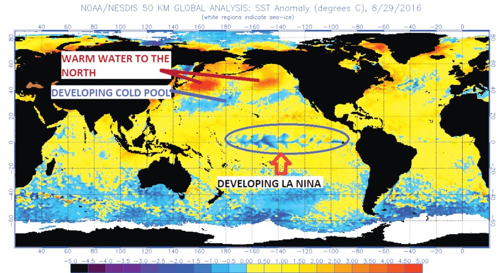
• Note developing La Niña (blue cool area across central Pacific)
• Note developing cold pools across north-central Pacific with warm pools to the north.
While you can clearly see the developing La Niña signature across the equatorial Pacific as well as the developing cold/warm pools across the north-central Pacific, lots of questions remain about how things will progress over the next two to three months.
If the La Niña were to strengthen into a strong event, the odds of a cold winter would quickly dissipate. Right now it is moving into the weak range, and most modeling does not suggest a moderate or strong event. But our ability to accurately forecast how La Niña or El Niño events will evolve is very limited. Last year there were late summer signs the El Niño was going to peak at moderate levels. But as we all know it exploded into a very strong El Niño and with it came the ensuing warm winter (or almost non-winter.)
The cold pool shown across the north-central Pacific is a very encouraging sign for those looking for a cold winter, in general. A cold pool with a warm pool to the north and warm conditions to its south is a very well documented signal for higher than normal jet stream heights across western Canada. With high western Canadian heights comes a pipeline for polar and or arctic air mass transportation into the central and eastern United States. How well the cold air delivery system develops is a function of other items that are not yet predictable, but if you want a chance at a cold eastern and/or central winter you like to see higher than normal jet stream heights across western Canada and the Arctic. So any further strengthening of this warm/cold/warm configuration will be considered a cold weather plus.
Model Trends
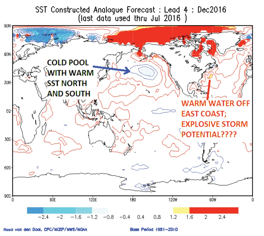
Here is the CSA Model winter sea-surface temperature anomaly for December 2016. This shows strong support for the idea mentioned above.
If the Pacific temperature pattern looks like this come December, odds would jump considerably in terms of a cold to very cold north-central U.S. with the cold building eastward during the course of the winter.
Also note the very warm ocean temps in the western Atlantic off the East Coast. While this could try to modify and limit the mid and late winter cold across the Northeast, it implies the potential for explosive nor’easter potential, which could help to pull cold air into the Northeast and help produce an above normal interior snowfall season.
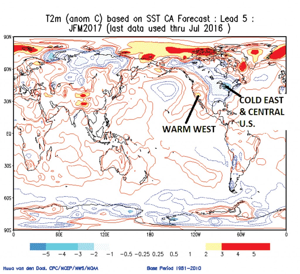
Here is what the CSA does with surface temperatures this winter! Interesting?
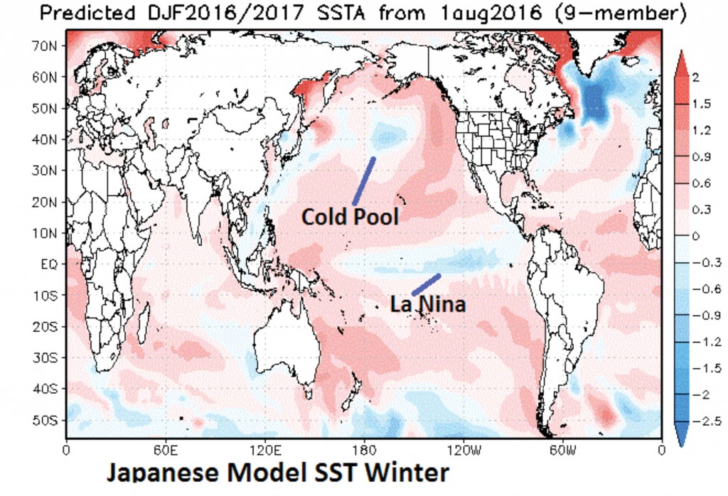
Here is the Japanese Model Pacific temperature forecast. Note again: La Niña signature and solid warm/cold pool/warm configuration to the north.
No one model forecast is a guarantee of getting the forecast right, but when you see multiple model forecasts on the same track, it does increase the level of confidence that the footprint selection might be on track.
The Japanese Model La Niña forecast is a bit more bullish, but not overwhelmingly so. The real key is that it is also showing the very solid cold signal configuration across the north-central Pacific.
The Japanese modeling of the surface temperature anomalies across North America has been wildly variable from month to month. Its Pacific temperature forecast has been pretty consistent, but its prediction of how the U.S. winter temperature pattern will end up has been much different with every new update. It has occasionally shown a warm winter, even with a good Pacific pattern for cold. I put more stock and value in the Pacific temperature forecast than the model U.S. temperatures prediction.
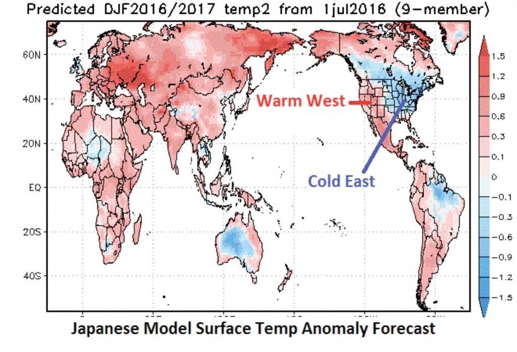
Here is one of its recent outlooks; it might be way overdone, but it does show you what could be on the table!
The American Model is often the weakest of the group. It appears to be on track with the Pacific temperature pattern, but has been less bullish on the cold for the central and eastern United States.
Once again, I do not put a lot of faith in the details, but look to see if the basic La Niña and north-central Pacific footprint are showing up.
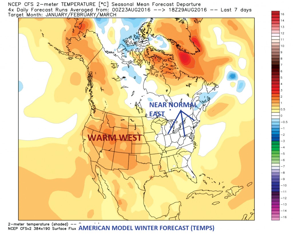
Here is its recent outlook for North America. Note it has the warm western winter forecast, but is less bullish on eastern cold. That being said, its prediction of a near normal winter temperature anomaly across the eastern U.S. is a positive in that it must be seeing the western ridging, and this opens the door for much colder predictions to follow as the model gets deeper in the fall season.
Current Modeling and Atmospheric Trends
Piecing together the different projections, here are the current modeling and atmospheric trends.
- Weak La Niña is likely.
- North-central Pacific temperature pattern appears to be evolving in a manner consistent with past winters that featured a cold north-central U.S. pattern that then expanded eastward into the Northeast states as the winter matured, as higher than normal jet stream heights developed across western Canada.
- Core of the cold may be most likely across Northern Plains and Upper Midwest.
- Small shifts in western ridge position and strength will play a big role in where best Arctic pipeline sets up.
- Any shift toward a strong La Niña would diminish cold air potential.
- Warm western Atlantic could prove conducive to strong East Coast or offshore storm development.
Forecast for 2016-2017 Winter
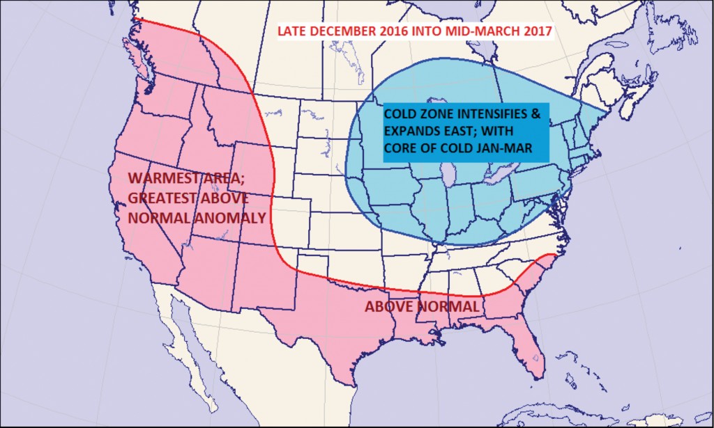
The heart of the winter season will be late December 2016 into mid-March 2017.
Assuming we are right about the combination of a weak La Niña being accompanied by a horseshoe “warm-cold-warm” pattern across the North Pacific, then I feel comfortable with the late December through February on into March anomaly pattern resembling the forecast map above.
There has also been growing data to indicate increasing support for high latitude blocking. The form, intensity and location of the main blocking center is far from a certainty, but in the grand scheme of things high latitude blocking is more often than not a good thing when looking for a cold winter across at least a portion of North America.
I am looking for the heart of the early winter cold to shift eastward into the eastern Great Lakes, Ohio Valley and Northeast and New England regions as we transition from the early winter pattern during middle to late December into the heart of the winter season from very late December on through January and February.
Whether or not the cold pattern comes bodily eastward and engulfs all of New England and the Northern Middle Atlantic will depend on where the mean western Canadian ridge develops and whether or not high latitude blocking starts to exert pressure on the large-scale pattern. Since there is at least a suggestion that high latitude blocking should induce a moderate to strong North Atlantic block, I have chosen to keep portions of northern and eastern Maine out of the cold anomaly at this time. This will need to be revisited in a month or two.
AUTHOR NOTES: Please remember a seasonal forecast map is meant to convey where the greatest potential of above normal or below normal temperature anomalies are most likely to be located. It is not meant to mean that everyday, every week or every 10-day period will be warmer or colder than normal within the forecast anomaly zones.
While I expect much of the Northeast to average milder than normal during the fall on into early December, there will be opportunities for cold periods, but they should not dominate the period. Conversely, the late December on into early March is expected to average colder than normal, but there will be milder than normal days or even a couple of milder than normal weeks.
Meteorologist John Bagioni of Fax-Alert Weather Service can be reached at (860) 675-9091 or john@faxalertweather.com.
